Gis Analysis
Advertisement
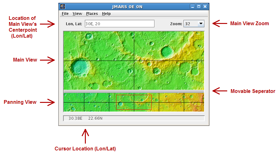
JMARS v.1.25
JMARS is an acronym that stands for Java Mission-planning and Analysis for Remote Sensing.
Advertisement

Autodesk Infrastructure Design Suite v.2013
AutodeskT« Infrastructure Design Suite is a comprehensive software solution combining the tools to plan, design, build, and manage utility and civil infrastructure.

Grass GIS for Mac OS X 6.4.1-3 v.3
Commonly referred to as GRASS, this is a free Geographic Information System (GIS) used for geospatial data management and analysis, image processing, graphics/maps production, spatial modeling, and visualization.
My World GIS v.4. 1. 2011
My World GIS™ is a Geographic Information System (GIS) designed specifically for use in middle school through college classrooms.
Quantum GIS v.1.8.0
Cross-platform and user friendly Open Source Geographic Information System (GIS). Quantum GIS (QGIS) is a user friendly Open Source Geographic Information System (GIS) that runs on Linux, Unix, Mac OSX, and Windows. QGIS supports vector, raster,
ESBStats - Statistical Analysis Software
Statistical Analysis and Inference Software for Windows covering everything from Average, Mode and Variance through to Hypothesis Analysis, Time Series and Linear Regression. Includes Online Help, Tutorials, Graphs, Summaries, Import/Export, Customisable

Screenplay Analysis Software
Screenplay Analysis Software, Hero's Journey, Monomyth, Screenwriting, Screenplay Writing, Story Structure, Screenplay Structure, Screenwriting Structure, Storytelling, Storytelling Structure, Act Structure, Drama Structure
Investment Analysis Software
Easily analyze the performance of any investment by applying basic input variables to build an investment analysis. Analysis generates equivalent current year values allowing comparisons between different investments and identifies investment performance

Icons-Land Vista Style GIS/GPS/MAP Icon Set v.2.0
Vista Style GIS/GPS/Map Icon Set is of perfect design quality. Being represented in 7 sizes, icons can be widely used in local service applications, GPS tracking and GIS applications, and any kind of mapping applications.
XpoLog Log Management and Analysis
XpoLog log management and analysis platform generates usage reports on applications logs from production, helping testers to understand how the applications are used, and where to focus the testing efforts. Discovery of errors during testing, snapshots of